![]()
Highway project Development
Understanding the needs of the future regional highway system starts with development patterns. Where will future development occur, where will job centers form, high density rise, activity centers develop? To better understand and predict growth and its impacts on the urban landscape, the MPO first collaborates with its member jurisdictions to analyze local land use and transportation plans, development plans, and vision work. This is then paired with state produced socio-economic demographic projections data to plot out where land capacity can accept growth. The MPO uses the sophisticated Wasatch Front-wide land use model and travel model to predict where people will live and jobs will concentrate in order to understand where future congestion might occur. Corridors that show congestion and are currently under built have proposed widening improvement projects in the plan. New corridors to add proper spacing of various types of highways are also listed in the plan. Projects and systems to improve the efficiency of the system are also proposed. In order to accommodate planned growth, Utah County’s regional highway network must grow and expand. New and improved arterials, expressways, and freeways all are needed to create the urban highway grid of our future.
![]()
learn more
Stakeholder and Public Outreach
![]()
learn more
Travel Demand Modeling and Volume Maps
![]()
Major Highway projects
As a growing area, connecting the highway grid includes expanding and creating new major highways. Freeways, expressways, and arterials all form the major backbone of regional traffic movement. Proper sizing and spacing of these facilities is key. The projects below are the new and expanded freeway and expressway projects proposed in TransPlan50.
I-15 FreeWay Projects
The I-15 freeway is the economic and mobility lifeline of Utah County and the Wasatch Front. Running from Canada nearly to Mexico, our regional economy, as well as our quality of life, is directly tied to it. From 2012 through 2020, multiple projects have reconstructed and widened the freeway between Payson and Salt Lake County.
Today, Utah County lacks a connected highway grid. This lack of connections requires most regional and many local trips to funnel onto I-15. By 2040, even at its current twelve lanes through Lindon, anticipated growth creates high congestion during peak hours. Geographic choke points in the Lindon, Springville, and Point of the Mountain areas experience some of the worst congestion in the region due to a lack of redundant routes.
Options for the I-15 corridor include widening the freeway south of Orem to twelve lanes, building a frontage road system or collector-distributor system on each side of the freeway, or adding multiple express lanes down the middle of the freeway. Each of these solutions has benefits and impacts. All require additional study and collaboration with the various transportation stakeholders along the corridor.
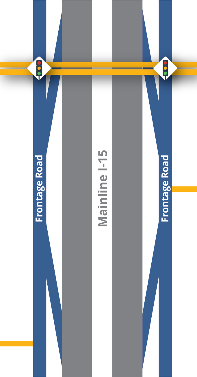
Frontage Road System
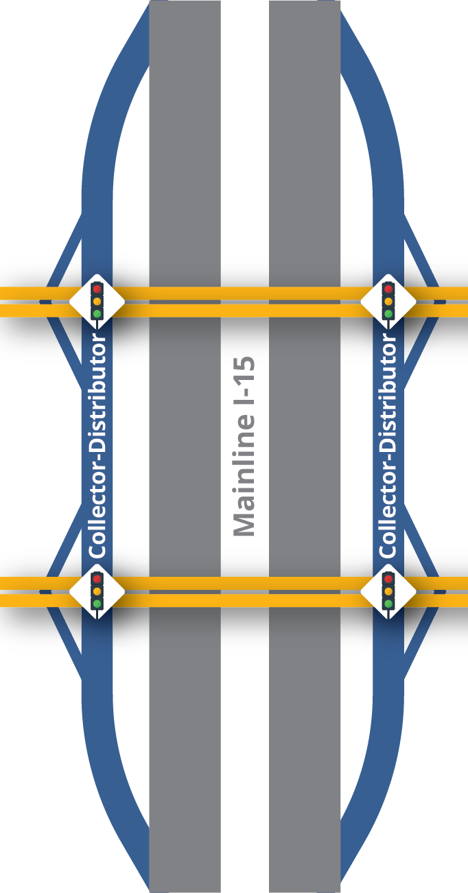
Collector-Distributor System
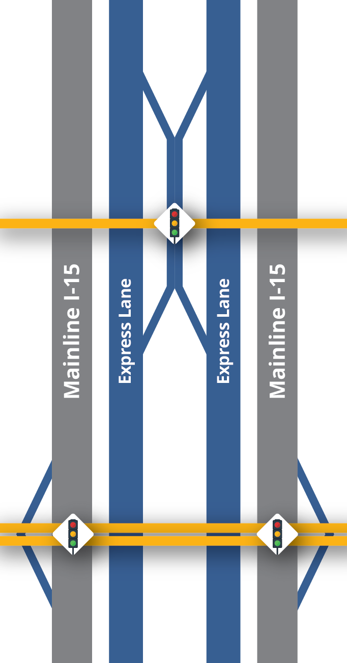
Add Multiple Express Lanes
Click on the different I-15 projects on the map below to learn more about the needed phase, fiscally constrained phase, and cost associated with each project.
Other Major Highway Projects
Click on the different major highway projects on the map below to learn more about the needed phase, fiscally constrained phase, and cost associated with each project.
![]()
Arterial Roadway projects
Besides the major highway projects, there are 70 arterial road projects within TransPlan50. These roads range in size, lanes, speeds, and other characteristics and include streets like State St, University AVE, Spanish Fork Main ST, and Pony Express PKWY. An arterial is a road meant primarily for through movement of vehicles at a moderate speed, although some access to abutting property is expected. These are the main thoroughfares that move traffic and serve businesses and higher-density residential areas.
Click on the different arterial projects on the map below to learn more about the needed phase, fiscally constrained phase, and cost associated with each project.
![]()
Needed Projects Costs & Funding Availability
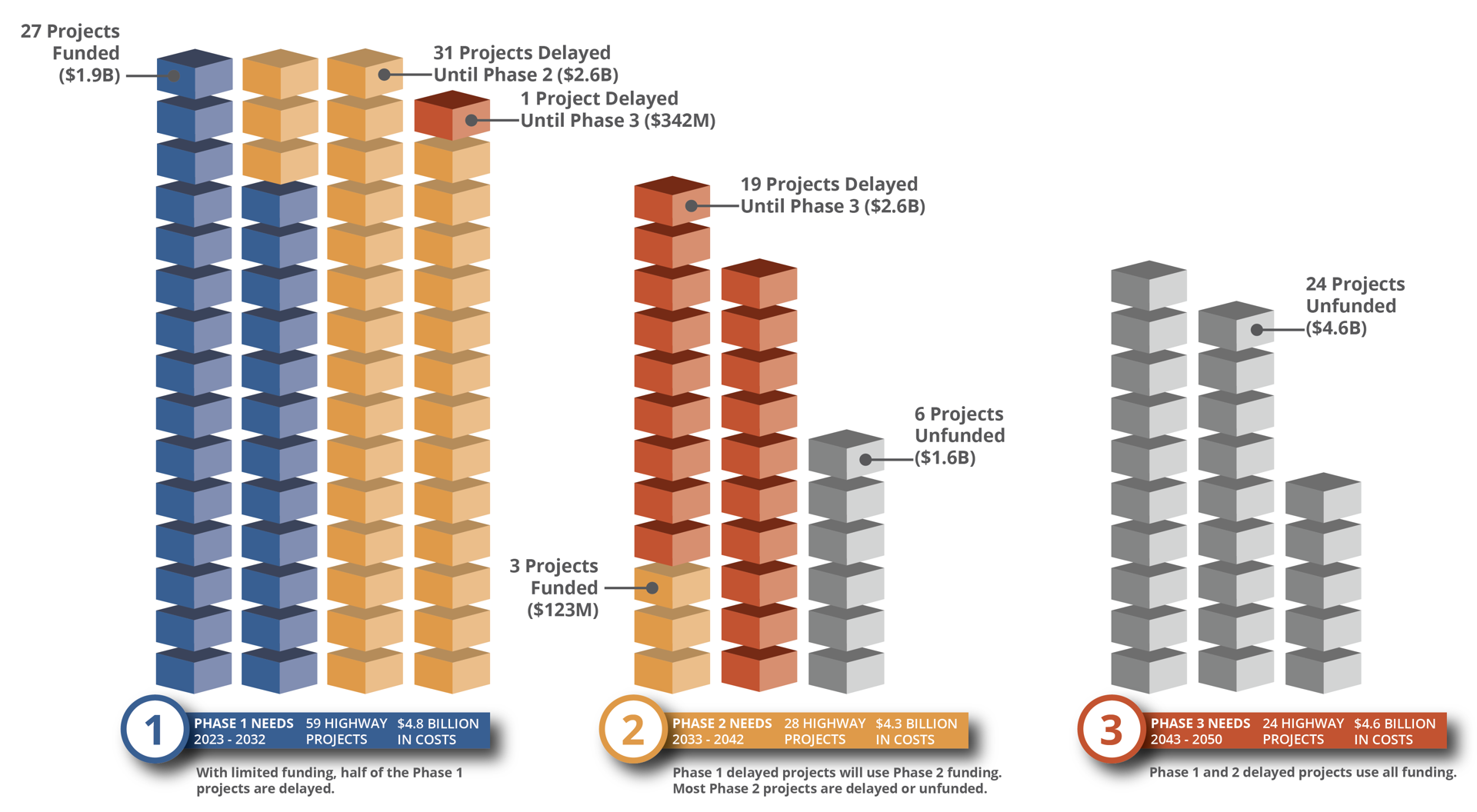
Federal air quality regulations require the RTP to conform to air quality standards, including constraining costs to proposed available funding. This planning cycle, high inflation and escalating land values have led to project costs being up over 38% since 2019. Funding for transportation projects is very limited, down 68% from 2019 projections. The Transportation Investment Fund (TIF) is a significant funding source for highway projects in Utah and is currently programmed to 2030 at $7.2 billion statewide. The 2019 MAG RTP planned on receiving 22% of these funds but the region is programmed for only 10%. With significantly less funding for the first ten years, needed projects get delayed decades, with many unfunded. With escalated costs and less revenue, the fiscally constrained project list contains significantly fewer projects in this planning cycle.
![]()
Highway Maps
Needed & Fiscally constrained Projects
These maps show all the highway projects planned in TransPlan50.
Slide between the left map, which shows projects by needed phase, and the right, which shows when funding is planned to be available.